FOCA Aquatic Invasive Species Prevention & Monitoring Program
Tips for Boaters
Some aquatic species can survive more than two weeks out of water
Before you go
Visually inspect your boat, motor, trailer, and all fishing gear. Look for aquatic debris that might be dried and still clinging to your equipment since the last outing. Washing and/or drying your equipment will kill harmful invasive species.
Watch out
While on the water, steer your boat or watercraft clear of areas known to have invasive species. Propellers can cut up plants; and oars or paddles can break stems, further spreading invasive species. 3
When you leave
At the boat launch, inspect your boating equipment: boat, motor, trailer, rollers, axles, anchors, centerboards, and fishing gear, and remove any zebra mussels and/or other animals and plant debris (stems/leaves) that are visible. Dispose of debris in the garbage, or compost on land - never near any waterbody. Prior to leaving the boat launch, drain water from the motor, live well, bilge, and transom wells, and leave your drain plug out while traveling.
Found a suspected invasive species? Report it:
1-800-563-7711 or http://www.eddmaps.org/ontario/
Find it. Report it. Monitor it. Prevent the Spread.
Aquatic AIS Prevention & Monitoring Program - Federation of Ontario Cottagers’ Associations
Aquatic AIS Prevention & Monitoring Program - Federation of Ontario Cottagers’ Associations
Web: www.foca.on.ca/invasive-species/ | Email: info@foca.on.ca
Wildfire and Natural Vegetative Buffers
Summary
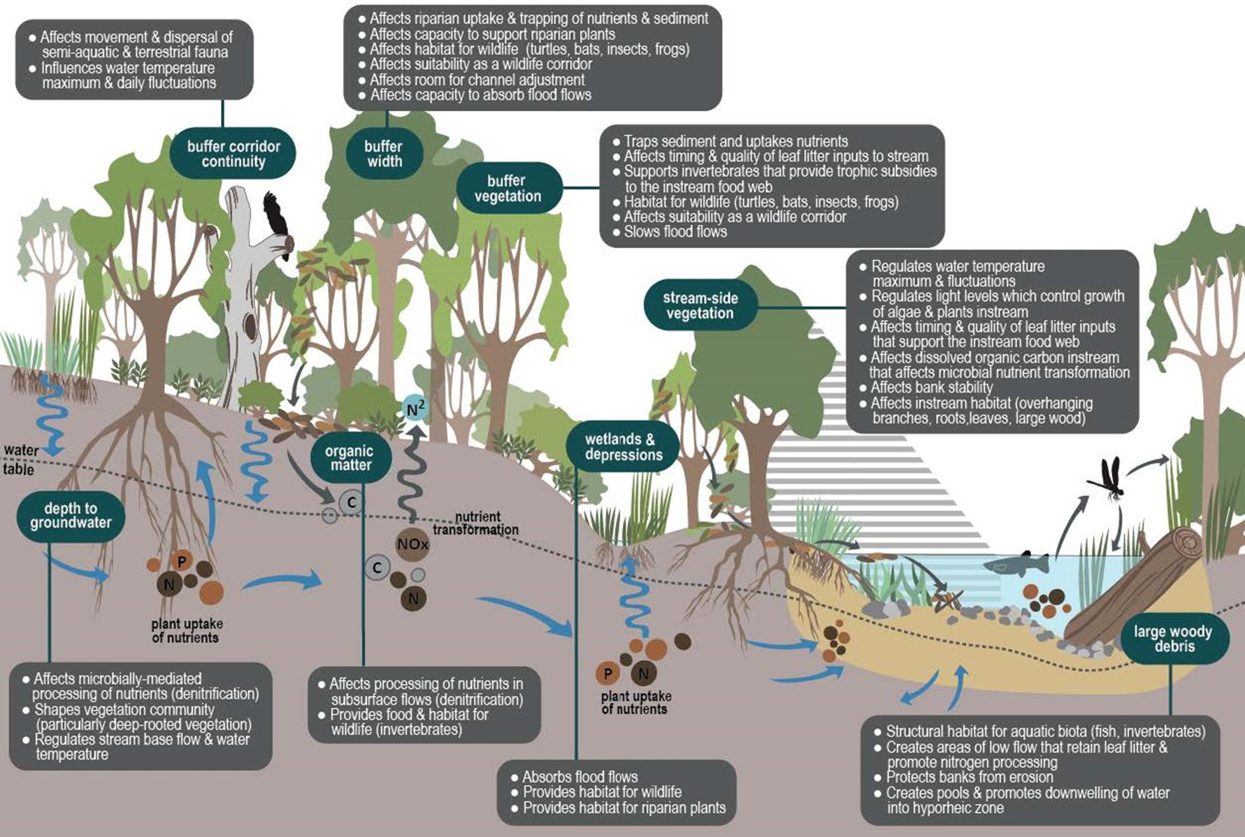
The Municipality is legislatively required to amend the Comprehensive Zoning Bylaw to increase the natural vegetative buffer along shorelines from 15 metres to 30 metres. Currently, the development of buildings and structures is not permitted within 30 metres of waterbodies and permanent watercourses.
The Ontario Ministry of Natural Resources and Forestry (MNRF) “Fire Smart” Initiative is a recommendation from the Ontario Ministry. The MNRF “Fire Smart” Initiative is not a legislative requirement.
Legislation
The Ontario Planning Act governs how Zoning Bylaws can be used for regulating the use and development of land. The Planning Act states that all decisions of the Council shall be consistent with the Provincial Policy Statement.
Subsection 26(9) of the Planning Act requires the Comprehensive Zoning Bylaw to be updated and amended to conform with the County of Hastings Official Plan when the Official Plan is updated. The Official Plan was updated in 2018. The proposed Bylaw 2022-005 will conform with the policies in the Official Plan as Ontario’s planning legislation requires.
Is a 30-metre natural vegetative buffer consistent with the Provincial Policy Statement?
The Ontario Ministry of Environment, Conservation and Parks (MECP) “recommends a minimum 30-metre setback from the highwater mark of water bodies as a standard in local Official Plans and related Comprehensive Zoning Bylaw and is consistent with Section 2.2.1 of the Provincial Policy Statement Part h) ‘ensuring consideration of environmental lake capacity.’ This is also in addition to Section 2.2.2 of the Provincial Policy Statement which states that ‘Development and site alteration shall be restricted in or near sensitive surface water features and sensitive ground water features such that these features and their related hydrologic function will be protected, improved or restored’.”
The Ontario Ministry of Environment, Conservation and Parks (MECP) supports a minimum setback of 30 metres “to provide protection to lakes, rivers and streams from inputs of nutrients and suspended sediment consistent with Section 2.2. Water - of the Provincial Policy Statement. These contaminants originate primarily from the disturbance 30-metre natural vegetative buffer
protects water quality and life mitigates surface runoff and septic effluent
Benefits of a Natural Vegetative Buffer
But the County of Hastings Official Plan says “should” which means it is not mandatory… right?
of soils, removal of natural vegetation, and hardening of the landscape which results in increased surface runoff in addition to the migration of septic effluent from tile fields. A minimum setback of 30 metres from a water body is also recommended for water quality protection purposes. Generally, the greater the setback from the water; the greater the level of water quality protection. The 30 m buffer strip has become a standard and has been supported before the Local Planning Appeal Tribunal (LPAT).”
Will a 30-metre natural vegetative buffer conform with the County of Hastings Official Plan?
Section 5.4.5.7 of the County of Hastings Official Plan states:
"In Waterfront areas, residential dwellings shall be set back as far from the shoreline as is practical, taking into consideration the size, shape and topography of the lot in question. Wherever feasible, the setback should be at least 30 metres from the high water mark and should remain undisturbed and naturally vegetated. Where the placement of an existing road will not allow this setback, the distance may be reduced to half the distance between the road and the water body, subject to the approval of a variance to the implementing Zoning By-law and to the site plan approval and provided the setback is not less than 20 metres. Residential infill structures may be set back from the high water mark in accordance with the established building line."
Section 5.4.5.8 of the County of Hastings Official Plan states:
"In Waterfront areas and adjacent to watercourses, a natural vegetative buffer strip a minimum of 30 metres in width should be maintained wherever possible from the seasonal high water mark to filter pollutants from run-off. Within this buffer area, the clear-cutting of trees shall be discouraged. On existing lots of records where a 30-metre setback from the high water mark is not possible, the setback may be reduced to the maximum setback possible, subject to the approval of a minor variance to the implementing Zoning By-law and to site plan approval. In order to determine the most appropriate building location for an existing lot of record, consideration should be given to reductions in other yard setbacks before considering reductions to the setback to the high water mark. A lesser buffer area may be required as determined by an approved environmental impact statement or site evaluation report pursuant to Part A - Sections 7.8.6 and 7.8.8 of this Plan that demonstrates that there will be no negative impact on the fish habitat and its ecological function."
But the County of Hastings Official Plan says “should” which means it is not mandatory… right?
Section 5.4.5.8 states "a natural vegetative buffer strip a minimum of 30 metres in width should be maintained wherever possible," and does not say "shall be maintained." Sections 5.4.5.7 and 5.4.5.8 are written with leniency and flexibility to permit "exceptions" to these Sections to provide enough flexibility for property owners to apply for minor variances from the zoning bylaw.
The Committee of Adjustment consists of five members and is tasked to decide whether a Minor Variance Application meets the following tests:
1. Minor in nature;
2. Desirable for the appropriate development or use of the land, building or structure;
3. Maintain the general intent and purpose of the Comprehensive Zoning Bylaw; and
4. Maintain the general intent and purpose of the County of Hastings Official Plan.
the
If Section 5.4.5.8 states "a natural vegetative buffer... shall be maintained," then a property owner proposing any development within 30 metres of the high water mark will fail the fourth test of a Minor Variance Application because the general intent and purpose of the Official Plan does not permit exceptions for development within 30 metres of the high water mark. The use of "shall" is very restrictive and prohibitive.
If Section 5.4.5.8 states "a natural vegetative buffer... shall be maintained," then a property owner proposing any development within 30 metres of the high water mark will fail the fourth test of a Minor Variance Application because the general intent and purpose of the Official Plan does not permit exceptions for development within 30 metres of the high water mark. The use of "shall" is very restrictive and prohibitive.
Instead, Section 5.4.5.8 of the Official Plan states "a natural vegetative buffer strip... should be maintained" which grants exceptions to this Section of the Official Plan and makes it possible to meet the fourth test of a minor variance, depending upon the Minor Variance Application. The use of "should" in the Official Plan is less restrictive than "shall" and allows for the possibility of relief from the Official Plan. If "shall" was used in the Official Plan, there would be no possibility for relief from the Official Plan without first obtaining approval for an Official Plan Amendment (OPA) before getting relief in a Minor Variance Application.
What is changing?
Currently, no development is permitted within 30 metres of the high water mark and a 15-metre natural vegetative buffer is required to be maintained along the shoreline.
Currently, there are no exceptions to clear within the 15-metre natural vegetative buffer.
The current 15-metre natural vegetative buffer does not conform with the updated County of Hastings Official Plan (2018)
The proposed Bylaw will increase the natural vegetative buffer from 15 metres to 30 metres while amending the zoning to permit exceptions in the natural vegetative buffer. The exception will allow the clearing of 25% of the shoreline frontage or up to 23 metres (75 feet), whichever is the lesser, of the 30-metre natural vegetative buffer.
The “Fire Smart” Initiative
Previously, the Hastings Highlands Fire Department (HHFD) created a synopsis of the Ontario Ministry of Natural Resources and Forestry (MNRF) “Fire Smart” initiative.
The MNRF’s “Fire Smart” Initiative contains variations and different recommendations to mitigate fires, including home maintenance, building materials, and choosing plants, shrubs and trees that are fire-resistant.
For example, the “FireSmart” Initiative recommends planting certain trees, such as poplar and birch trees, between 1.5 metres and 10 metres of a home as they are resistant to wildfire while avoiding highly flammable trees, such as spruce and fir. The full “FireSmart Begins at Home Manual” is available online.
The MNRF “Fire Smart” Initiative is a recommendation from the Ontario Ministry. It is not a legislative requirement.
Fire Safety Recommendations and Legislation for a Natural Vegetative Buffer
In most cases, property owners are able to meet the legislative requirement contained within the Municipality’s Comprehensive Zoning Bylaw and the recommended wildfire management strategies provided in the MNRF’s “FireSmart” Initiative.
However, in unique circumstances where property owners have a legal non-conforming residence that falls within the vegetative buffer and they have concerns with wildfire protection strategies, the Property Owner should consult with the Planning and Bylaw department prior to commencing any work. Providing a detailed work plan with site drawings and measurements will allow the applicable municipal department to provide any recommendations that may be required.
Credit: Hastings Highlands


FOAMING OF SURFACE WATERS:
A NATURAL PHENOMENON ON ONTARIO LAKES
A NATURAL PHENOMENON ON ONTARIO LAKES
WHAT CAUSES THE FOAMING OF SURFACE WATERS ON SOME ONTARIO LAKES?
The foaming of surface waters on lakes is not a new phenomenon. It is a natural process that has been going on for a long time. All lakes contain organic matter, such as algae, rooted aquatic plants, and leaves. When this organic matter decomposes through natural bacterial action, it releases cellular products to the water, which form a surfactant, or surface agent. A surfactant simply lessons the surface tension of the water, making it susceptible to foaming. When the wind blows, the waves on the lake agitate this surface agent, thus transforming it into sudsy white foam.
Natural foam is most noticeable along beaches exposed to the prevailing wind direction. When the foam reaches the shoreline, it tends to form a loose line where it mixes with tiny pieces of organic matter, which act as a binding agent and give it stability.
IS THIS FOAM HARMFUL TO FISH OR HUMANS?
Foam on surface waters is a harmless by-product of our lakes. Its chemical makeup is 99 per cent air and water, combined with one per cent or less surfactant.
WHAT ABOUT FOAM OF A POLLUTANT TYPE THAT MAY BE SEEN ON SOME LAKES?
Back in the 1950’s, manufacturers of laundry detergents marketed a type of product that was highly resistant to chemical breakdown. As a result, there was a foaming problem in the vicinity of all sewage treatment plant outfalls. Rivers with a bit of turbulence would often sprout huge, foaming white islands. In the early 1960’s, detergent manufacturers developed a new formula, which was designed to remain stable only for short periods of time before breaking down into its components. This largely solved the problem of the foaming of surface waters downstream of sewage treatment plants.
Phosphorus, contained in most detergents, also contributes to the foaming of surface waters. Scientists have recognized that phosphorus is the key nutrient stimulating algal growth in lakes and streams. Algae are one of the organic matters present in lakes. Its natural decomposition leads to the creation of a surfactant in water, which is transformed into foam by wind agitation.
In past years, approximately 50 per cent of the phosphorus in lakes and streams contributed by municipal sewage cam from detergents. Federal regulations reduced the phosphate (P2O5) content in laundry detergents from approximately 50 per cent to 20 per cent on Aug.1, 1970, and then to five per cent on Jan 1, 1973. However, automatic dishwashing compounds were not subject to government regulations and are consequently high in phosphorus. Many automatic dishwashers are present in resort areas-about 30 per cent of the cottages in the Muskoka Lakes, for example, have them. Cottagers, therefore, may unknowingly be contributing significant amounts of phosphorus to their lakes.
In past years, approximately 50 per cent of the phosphorus in lakes and streams contributed by municipal sewage cam from detergents. Federal regulations reduced the phosphate (P2O5) content in laundry detergents from approximately 50 per cent to 20 per cent on Aug.1, 1970, and then to five per cent on Jan 1, 1973. However, automatic dishwashing compounds were not subject to government regulations and are consequently high in phosphorus. Many automatic dishwashers are present in resort areas-about 30 per cent of the cottages in the Muskoka Lakes, for example, have them. Cottagers, therefore, may unknowingly be contributing significant amounts of phosphorus to their lakes.
WHY DOES NATURAL FOAMING OCCUR ON THE SURFACE OF SOME LAKES AND NOT OTHERS?
The appearance of natural foam on a lake is determined by the amount of organic plant material in the lake and the size of the area of open water (and thus its ability to provide extended wave action). Organic material, such as algae and vascular aquatic plants, lignins, tannins, and fulvic acid, accumulate in lakes after periods of heavy rainfall. Decomposition of this organic material produces compounds that are similar to the fatty acids used in soaps. Softwater lakes of the pre-Cambrian shield have a greater amount of these compounds and lower surface tension than hard-water Great Lakes, thus making them more susceptible to foaming.
In lakes where there is a long fetch (the distance from shore to shore in the direction of the wind), constant winds can induce a circulation pattern (Langmuir circulation) to occur. This circulation pattern causes foam, generated by wave action, to collect in long streaks (Langmuir streaks). Langmuir streaks are natural occurrences, composed of particulates and surface-active materials collected together in long ridges. When Langmuir streaks impinge on a shore, piles of foam may accumulate.
Credit: Information from the Ontario Environment Information Bulletin, December 1990, 703b 08/90-8M
WATCHING YOUR WAKE
Cottagers derive a great deal of enjoyment from a host of boating activities …
Those of us with our pleasure craft licence studied specific rules of the water geared to
safe & responsible boating; most of us are familiar with general boat safety & etiquette.
We may not be as familiar with the impact of boat wake.
Impact of Boat Wake
The larger the wake, the greater the potential for undesirable side effects
Loons, & other birds that nest along the shore, choose locations that are protected
from waves generated by the prevailing winds. However, boat wake, which can
come from any direction, can & does drown the nests & the young, particularly in
May & June.
Inexperienced swimmers & young children are not usually in the water when wind-driven the
waves are high. However, they can be toppled by the size & energy of boat
wake.
Boat wake & prop wash can churn up sediments in shallow water which releases
dormant nutrients that promote weed growth & algal blooms.
Boat wake can cause erosion.
Boat wake can cause docks & moored boats to rock severely & pull mooring
hardware.
Waves
Three factors make up wind-driven waves: the speed of the wind, the length of time the
the wind has blown, & the distance of open water that the wind blows over is called the fetch.
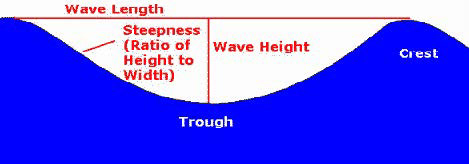
Waves are measured by
Height (from trough to crest)
Length (from crest to crest)
Steepness (angle between crest & trough)
Period (length of time between crests)
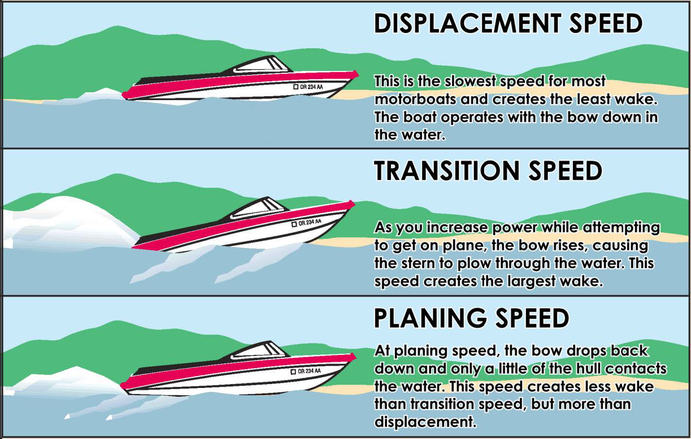
Boats moving through the water create waves, commonly known as wakes.
Observations made by the Oregon State Marine Board have shown the effects of three
speed zones: displacement, transition & planning.
Source: Understanding & Utilizing the Secrets of Waves
Factors that influence the size of the wake when it reaches shore include the speed of the boat & the distance the wake travels before it reaches shore.
Interestingly, the water particles themselves don’t move. Rather, their energy does. A wave's energy is proportional to the square of its height (potential). Thus, a 3m high wave has 3 x 3 = 9 times more energy than a 1m high wave. (Source: Oceanography: waves, theory & principles)
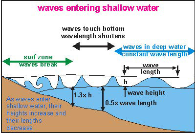
As waves enter shallow water, they slow down, grow taller & change shape. (Source: Oceanography: waves, theory & principles)
The movement of the particles along the bottom of the body of water can disturb the sediment on the bottom &, thereby, release nutrients.
Waves & Erosion
Natural causes of shoreline erosion include wind-driven waves, water levels, ice, slope of the bank, & the absence of vegetation. Human causes include the removal of rocks, trees, shrubs, & other vegetation along the shoreline, retaining walls, & wave action from passing boats.
The size of the watercourse affects the potential for erosion to occur. The greater the distance the waves are generated from shore, the more opportunity they have to dissipate before reaching shore.
Wave height is one of the most important factors in shoreline erosion. Observations made by the Minnesota Department of Natural Resources have shown that
a wave that is 12.5 cm high (the height of a compact disk case) when it reaches the shore does not cause significant shoreline damage. Waves this high are created by boats operating at speeds under 10 km/h – a speed that is generally considered reasonable when operating close to shore
a wave that is 25 cm high is four times more destructive than a 12.5 cm wave
62.5 cm high waves are 25 times more destructive
(Source: Shoreline Erosion Caused by Boat Wake)
Runabouts & waterski boats produce a 25 cm high wave at the stern of the boat when at planning speed.
a wave that is 25 cm high is four times more destructive than a 12.5 cm wave
62.5 cm high waves are 25 times more destructive
(Source: Shoreline Erosion Caused by Boat Wake)
Runabouts & waterski boats produce a 25 cm high wave at the stern of the boat when at planning speed.
Wakeboard boats create a wake of half a metre or more.
The large waves produced by wakeboard boats don’t always have the distance needed to dissipate before reaching shore on many of our lakes in eastern Ontario. Hence, they can create a greater negative impact than other boats.
However, all boaters need to be aware of the size of the wake they create.
Legislation & Recommendations
The Small Vessel Regulations stipulate that the legal speed limit for all motor boats is 10 km/h within 30 metres of any shore.
Waterski & Wakeboard Canada strongly recommends that wakeboard boats stay a minimum of 50 metres from any shore & in a minimum of 2 metres depth of water to reduce the effect of shoreline degradation & turbidity.
A number of governments & government agencies, as well as local organizations in Canada & the US are struggling with how to deal with the erosion & safety issues associated with wakeboarding. For example,
The Safe Quiet Boating Association in the Muskoka Lakes area is working to change the legislation so that wakeboard boats operate 100 metres from shore.
The District of Lake of the Woods Cottagers Association has recommended that wakeboard boats operate 300 metres from shore to allow waves to lose their energy before reaching shore.
How You can be Wake Wise
1. Be aware of the size of your wake during displacement, transition & planning speeds.
2. Position your passengers through-out the boat in order to reduce the time spent in transition speed.
3. Look behind you to see & understand the impact of your wake on shorelines, docks or other structures. Adjust your speed & direction to minimize the impact.
4. Respect the shoreline zone. Reduce your speed to less than 10 km/h within 30 metres of any shore including the narrow channels between islands.
5. Water-ski, tube, & wake-board well away from all shorelines. Try to make use of the entire length of the lake.
6. Consider the size of the wake produced when purchasing a new boat.
Sources
Anthoni, Dr. J. Floor, 2000, Oceanography: waves, theory & principles of waves, how they work & what causes them
Apslund, Timothy R., Wisconsin Department of Natural Resources, Bureau of Integrated Science Services & University of Wisconsin, Water Chemistry Program, 2000, The Effects of Motorized Watercraft on Aquatic Ecosystems
Association PSLL, June 2011, Attention Boaters on Barnes, Bataille & Rheaume Lakes: Wake-Boats Banned from Lac Bataille Boat Launch
Environment Canada, 2005, Shoreline Erosion caused by Boat Wake
Federation of Ontario Cottagers Association (FOCA), Boating & the Environment
Holben, Jay, Understanding & Utilizing the Secrets of Waves, Boat Safe.com
Lake of the Woods District Property Owners Association, 2012, Causes & Effects of Shoreline Erosion Paper courtesy of the Pike Lake Community Association May 2013, Lake of the Woods District Property Owners Association, in collaboration with the Ontario Ministry of Natural Resources & the Mid-Canada Marine Dealers Association, Watch You Wake
Leenhouts, Doug, The Differences between Wakeboard Boats vs. Ski Boats
Muskoka Lake Cottagers Association in collaboration with the Ontario Ministry of the Environment, Wakeboard & Wakesurf Boats
Muskoka Watershed Council, Wakeboarding, Having Fun While Watching Your Wake
Oregon State Marine Board, 2003, Watching You Wake: A Boater’s Guide
Rees, Terry, Executive Director, Federation of Ontario Cottagers Association (FOCA), 2012, personal correspondence with Kay Rogers
Report prepared for Parks Canada, 2008, Risk Assessment of the Rideau Canal System (Northern Sector) a question of balance
The Safe & Quiet Boating Association, Muskoka Lakes
Tuckerman, Gerard, Manager of Natural Resources, Great Lakes Council, Wakeboards banned on the Wallamba River effective February 1, 2011
Water Ski & Wakeboard Canada, Guide to Understanding & Addressing Environmental Issues
